ASE-Spot1south

Naples Capodichino Intl. Airport – Spotting Guide
January 23, 2021
Hilo Intl. Airport -Spotting Guide
January 27, 2021
Naples Capodichino Intl. Airport – Spotting Guide
January 23, 2021
Hilo Intl. Airport -Spotting Guide
January 27, 2021Aspen-Pitkin County Airport – Spotting Guide

Aspen Pitkin Airport (ASE/KASE) is located 3.7 miles to the North West of Aspen, Colorado. It was opened in 1946 as a privately owned, public use gravel landing strip and in 1956 became a publicly owned airport serving Pitkin County. It has a single terminal building located on the eastern side of the runway with a frontage to Highway 8. It has a car park, access to rental vehicles and is well served with public transport. The business jet apron can be see from Highway 8 and Airport Road but be aware that exclusive private jet users do not take kindly to having their toys or presence photographed close up.
Aspen has a field elevation of 7,838ft amsl with a single asphalt runway and the opening hours are 0700-2300. The airport has a flight training school and is mainly served by business/private jets. Regular scheduled services are operated by SkyWest on behalf of American Eagle, United Express and Delta Connection using CRJ-700s. There is a wide variety of business jet movements, especially during the ski season.
You won’t see aircraft with a wingspan of greater than 95 feet and a gross Landing Weight in excess of 100,000 pounds dual wheel or 160,000 pounds dual tandem wheel.
Written by Andy Foscena, Konstantin von Wedelstaedt, Sandra and Watts Brooks. Last Update: September 2024 (Spot 5 added)
| Rating | |
| Movements | |
| Airline Variety | |
| Photo Locations | |
| Weather | |
| Airport Information | |
| Runways | |
| 15/33 | 2440m/8006ft asphalt |
| Terminals | Single terminal handling all flights. |
| Spotting Information | |
| Ladder | Not required. |
| Car/Public Transport | Buttermilk Ski Resort car park nearby which also has a bus stop, but a car is recommended as public transport to the spots is not that good. |
| Restrooms + Drinks/Food |
In the Airport terminal and ButtermilkSki Resort. Plus east of the airport terminal in the housing area there are also some restaurants. |
| Hotels | None around, nearest are in Aspen itsself. |
| Season | In winter you will have a lot of GA and charter traffic but due to the north/south direction of the runway you won’t have the sun for a long time on each side of it. |
| Security | Be aware that exclusive private jet users do not take kindly to having their toys or presence photographed close up. |
| Runway Usage | |
| General Info | Due to mountains around all arrivals taking place on 15 and departures on 33. Only small props are possible to use 33 for arrivals but it necessitates a high approach without overflying the town of Aspen. |
| Spot #1 – W Buttermilk Rd – 33 movements + Airport Overview | |
|---|---|
| WHERE | This spot can be found all along W Buttermilk Rd. You can park on the layby or at the Buttermilk Ski Resort car park (called Aspen Parking) and then walk up from there. The walk is uphill and takes about ten minutes, however you can also cary your position freely along W Buttermilk Rd here, so the walk may also take a bit longer to its northern end where the road makes a left turn up the hill. |
| WHAT | Elevated view of full length runway 33 line up and intersection departures. 33 Arrivals plus late roll out and vacating runway after 15 movements may also be possible. |
| TIME | Midday to evening |
| MISC. | This is quite a step a hill so be careful where you stand as there is a risk of slipping down the hill. Also be aware of fast drivers, so park and walk safely and carefully. Runway 15 arriving aircraft affected by heat haze on final approach. |
| FOCAL LENGTH | 40-400mm Airport Overview = 40mm / Aircraft movements > 260mm (all examples except the overview below taken with 266mm and not cropped) |
Southern end – the bulge by the roadside:
Northernd end – 180 degree left turn towards the mountain in the west:
| Spot #2 – Owl Creek Rd – 33 movements | |
|---|---|
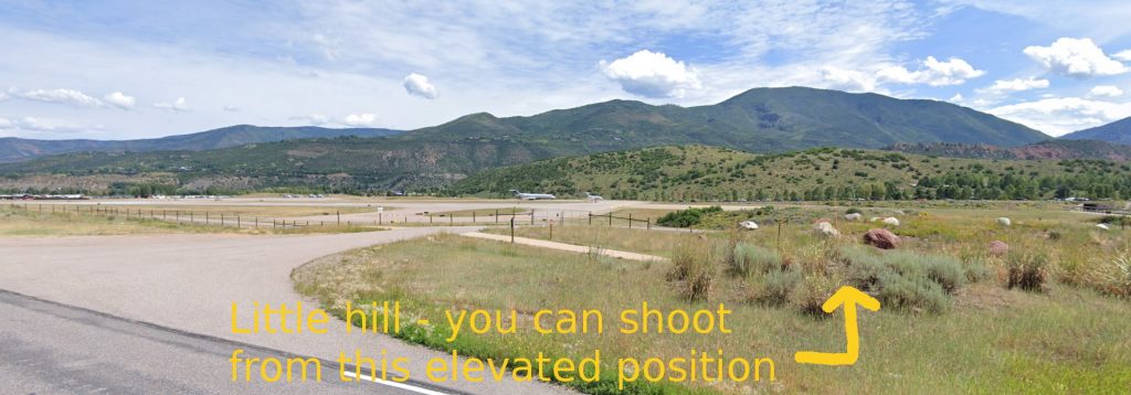
| WHERE | Exit highway 82 and drive along Owl Creek Rd. Turn right at first exit which is an emergency entrance for the airport. You can park here at either side of the side road and you will see the Owl Creek Trail crossing left to right – a few steps to the right/south you will see a little hill or at least elevated area with some rocks from where you can shoot over the fence a bit. |
| WHAT | You can see all 33 movements here (line-ups and arrivals) and also late vacators from runway 15. |
| TIME | Midday to evening. |
| MISC. | DO NOT BLOCK the gates or side road leading to the gates. Nothing around |
| FOCAL LENGTH | 100-400mm All examples not cropped and taken with 266mm |

| Spot #3 – Car Park Owl Creek Road – All movements + business jet apron | |
|---|---|
| WHERE | Continue from spot #3 along Owl Creek Rd until road bends towards the mountains. There is an official building with a car park on the airport side of the road. From the the car park you can shoot over the fence, but enter at own risk as this is a FAA facility. Ask security if it is ok to access the car park to take photos. Expect to be turned away as they are not keen for anyone to take photos of business jets. You can however stand on the pavement for Owl Creek Rd outside the car park since you are not on private property and try to shoot thru the fence a bit south.
We marked both on the map – the position one should head for in the car park and the alternative outside if you are being turned down. |
| WHAT | All airport movements: takeoffs, landings and the business jet apron. |
| TIME | Midday to evening. |
| MISC. | Enter at own risk as this is a FAA facility. Ask security if it is ok to access the car park to take photos. Expect to be turned away as they are not keen for anyone to take photos of business jets. You can however stand on the pavement for Owl Creek Rd outside the car park since you are not on private property. Little ladderstand with 1-2 steps may be helpful if you have to shoot from outside as you can thus shoot over the fence. Haze can be an issue though on hot days here. |
| FOCAL LENGTH | 70-300mm CRJ9 on runway = 110mm / Apron overview = 270mm |
| Spot #4 – Parking lot – Most Runway + Taxiway movements | |
|---|---|
| WHERE | This spot can be found in a big parking lot just south of the official ASE passenger terminal. It can be reached from the Airport Rd only when coming from the north. Pass the terminal on your left and head for “Economy parking” west of you. Once you followed the signs till the end, you should end up in a big parking area next to the fence. Get rid of your car here and search your favourite position along the fence easily. Spot can be easily reached from the terminal by foot. |
| WHAT | Due to the common runway procedure all flights departure on 33 and passing by for line-up. Most arrivals on 15 will pass by as they use the last rwy exits. |
| TIME | Sunrise till early noon. |
| MISC. | Keep a very low profile here! If you attract attention, you may be sent away by airport/parking security staff. Little ladderstand with 1-2 steps is helpful otherwise shot through the mesh. |
| FOCAL LENGTH | Falcon = 25mm, Dash = 20mm |
easymedia-gallery med=”51238″]
| Spot #5 – Viewing Area – All movements | |
|---|---|
| WHERE | Spot is located next to the terminal (departures entrance). You can park either on Bear Lot or Elk Lot (6 USD per hour, first 30 minutes free, info 2024). When parking at Bear Lot, cross the street (W Airport Road) and walk up the hill with the sign ‘Viewing Area’. When parking at Elk Lot, walk north to the terminal and walk up the hill with the sign ‘Viewing Area’ about 70m north of the terminal. The position is elevated and the use of a ladder is not necessary.
It is also possible to walk over the hill and take pictures of some business jets parked next to the fence. |
| WHAT | All airport movements: take-offs, landings and the business jet apron. |
| TIME | Sunrise to noon |
| MISC. | Food, drinks, restrooms are available in the terminal close by. |
| FOCAL LENGTH | 10-200mm |


