EHGR-Spot1

Omaha Eppley Airport – Spotting Guide
February 16, 2021
Brindisi Casale – Spotting Guide
February 23, 2021
Omaha Eppley Airport – Spotting Guide
February 16, 2021
Brindisi Casale – Spotting Guide
February 23, 2021Gilze-Rijen Air Base – Spotting Guide

Gilze-Rijen Air Base (ICAO: EHGR) is the main helicopter base of the Royal Netherlands Air Force. The helicopters based here are part of the DHC (Defense Helicopter Command). The second base which is part of the DHC is De Kooy in Den-Helder and is the oldest airfield in the Netherlands. Gilze-Rijen is with distance the best on-base spot in the Netherlands where you can catch helicopters. There are three operational squadron based at Gilze-Rijen, namely; the 298 Squadron operating the CH-47 Chinook, the 300 Squadron operating the AS532 Cougar and the 301 Squadron operating the AH-64 Apache. The airbase is daily quite active, normally about 6 to 8 helicopters on average are active flying multiple missions per day. Gilze-Rijen is for a military base very spotting friendly as spotters are tolerated along the fence around the airbase. The helicopters use also several training areas on the airbase of which some of them offer good photography spots. In the past the airbase was a fighter base, thats why there are still shelters present at the airbase. The fighters left the airbase in 1995 and at the same time the first helicopters were based here. Once in the few years Gilze-Rijen is one of the airbases which is hosting the Dutch Air Force Days (Luchtmachtdagen).
Gilze-Rijen is one of the best spots to see the Dutch helicopters from a very close range in some cases. Specially at the Slopes South the helicopters are coming very close to you. Spotters are grouped in a spotting group called GRAS (Gilze-Rijen Aviation Society), visit their website for more info like background of the units and scanner info at www.gras-spotters.nl For more photos taken on this base also check the website www.runway28.nl
Written by Alex van Noye. Last Update: 2020
| Rating | |
| Movements | |
| Photo Locations | |
| Weather | |
| Airport Information | |
| Runways | |
| 02/20 | 1996m – Asphalt |
| 10/28 | 2779m – Asphalt |
| Areas | |
| Area #1 | Platform 301 Squadron. Here are the AH-64 Apache helicopters located. |
| Area #2 | Platform 300 Squadron. Here are the AS532 Cougar helicopters located. |
| Area #3 | Platform 298 Squadron. Here are the CH-47 Chinook helicopters located. |
| Area #4 | Slopes South. This training area has two slopes for helicopter training. |
| Area #5 | Platform Historical Flight RNLAF. Here are the historical aircraft located. |
| Area #6 | Platform Hot Refueling. Helicopters are refuuled at this spot. |
| Area #7 | Cargo/Visitor Platform. Here most visitors are parked and stored. |
| Area #8 | Drop Point Bambi Bucket. here the helicopter pick up the Bambi Buckets for forest fire fighting. |
| Area #9 | Sling East. Here helicopters can pick up & drop of slings loads for training. |
| Area #10 | Sling West. Here helicopters can pick up & drop of slings loads for training. |
| Area #11 | Slopes North. This training area has one slope for helicopter training. |
| Spotting Information | |
| Ladder | Yes for spots #4, #6, #7, #8 and sometimes for spots #2 and #3 depending on the height of the bush along the fence |
| Car/Public Transport | You can get into railway station Gilze-Rijen. From there you can get the bus line 130 towards Tilburg. Step out at the Burgermeester Ballingsweg and walk towards the Runway 28 landing area. You can also stay in the bus until Nerhoven in Gilze and walk towards the Slopes South if needed. This are the only spots reacable by public transport. |
| Restrooms | There are no restrooms at this airbase, it is a military operational field therefore you need to go to the closest restaurant or the Shell fuel station if you need facilites (Shell is visible on the map). |
| Drinks/Food | There are a few restaurants in the area and there is in Rijen one Shell fuel station where they sell sandwhiches and coffee. The location is marked on the map. |
| Hotels | The best option is to stay in the Van Der Valk Hotel Gilze-Tilburg (visible on the map). |
| Season | Gilze-Rijen is active through the whole year. In summer mainly during day time from 0900 – 1600LT. In the winter months (September – April) the base is also flying in the evening hours in the darkness. Be aware that flight operations are mostly very limited until noon. All spots are good accesable with respect to the distance. Only taking photos on the platforms can give heat haze when its warm in summer. |
| Security | Be aware that Gilze-Rijen is an operational military airbase of the Royal Netherlands Air Force. Spotting at this base is not a problem, the security is used to many enthousiast which are present araound the airbase. It is torleated to use ladders at spots like the Runway 20 and the Slopes South. But be aware that when security asks you to remove it that you will obey them, but like said in 99% of the cases they allow it. The usage of scanners to listen to the ATC is allowed in the Netherlands, so thats not a problem. When standing at Runway 28, please keep in mind that you will not stay between the blue warning boards which says “Danger Low Flying Planes”. These signs are located between the traffic lights and standing still in between is seen as a flight safety risk and security will visit you! |
| Runway Usage | |
| General Info | Runway 28 is the primairy direction of the airbase. But be aware that helicopters don’t need a runway and can land everywhere on the base where needed. |
| 02/20 | Is mainly used for circuit flying with southern and northern winds. In many cases the helicopters also use this runway for take-off and landing when they visit the hot refuelling area. |
| 10/28 | Is used during take-off and landings of the helicopters. the direction depends on the wind. Also circuits are flown here with western and eastern winds. |
| Spot #1 – Official Spotting Area – Landing Runway 28, Droppoint Bambi Bucket | |
|---|---|
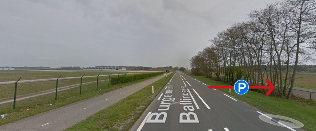
| WHERE | Park your car at the official parking of the spotter area. When coming by bus take the bus from the railway station in Gilze-Rijen and take bus line 130 to Tilburg. Step out of the bus at busstop Burgermeester Ballingsweg (Bus Stop #1) and walk to the spotter area. For the landing no ladder needed. |
| WHAT | At this spot you can take photos of the landing aircraft or helicopters at the Runway 28. Also you can take photos of the helicopters which will pick up a Bambi Bucket in Area #8. |
| TIME | This spot is during day time always available for landing shots as the sun is always in your back. For the Bambi Pick up point the morning hours are the best, after noon you will have back light. |
| MISC. | No facilities available. |
| FOCAL LENGTH | Landing Runway 28 about 70 to 100mm for large aircraft, about 200mm for small aircraft. |
| Spot #2 – Burgermeester Ballingsweg Middle – Line up Runway 28 and Taxi Track | |
|---|---|
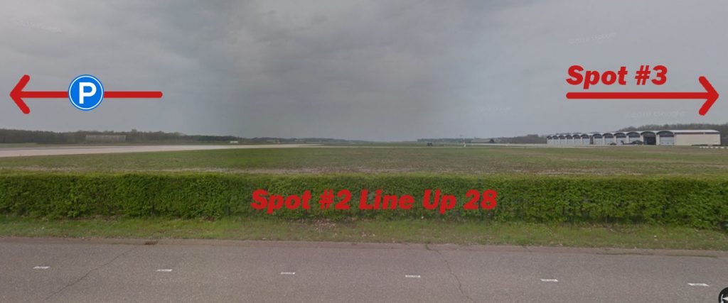
| WHERE | First follow the same instructions given spot #1 already regarding parking and bus transport. But at the end, walk to the other side of the road now, also cross the bycicle path and position yourself just somewhere along the fence around the runway 10/28’s head. |
| WHAT | Here you can take photos of the helicopters or aircraft which are lining up at Runway 28. |
| TIME | Until 1200LT it is the best time as the light is still on the nose of helicopters coming towards you. The rest of the day still a good spot but you need to changes angles as the light is coming from the side from the south. This is also the spot where the famous sunset shots are made of the DHC helicopters at the beginning og the evening. The best period for these shots is late September. |
| MISC. | No facilities available. Ladder sometimes needed if the bushes are too high. |
| FOCAL LENGTH | 200mm for side shots of Apaches on the front taxi track Lima. Up to 400mm for interesting angles and helicopters lining up via back taxi track Kilo. |
| Spot #3 – Burgermeester Ballingsweg North – 301 Squadron Platform | |
|---|---|
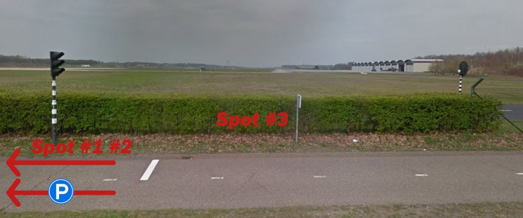
| WHERE | Yet again follow the instructions given spot #1 already regarding parking and bus transport. But again, walk to the other side of the road, cross the bycicle path and now position yourself along the fence a bit more north. Roughly at the bicycle traffic lights (where the bushrow becomes a fence) as here you are at the taxiway’s head. |
| WHAT | When helicopters will leave from Lima, you can take frontal shots of the Apaches on the taxi track along the platform. |
| TIME | Until 1200LT it is the best time as the light is still on the nose of helicopters coming towards you. The rest of the day still a good spot but you need to changes angles as the light is coming from the side from the south. |
| MISC. | No facilities available. Ladder sometimes needed if the bushes are too high. |
| FOCAL LENGTH | Frontal shots and platform shots of parked Apaches with 400mm |
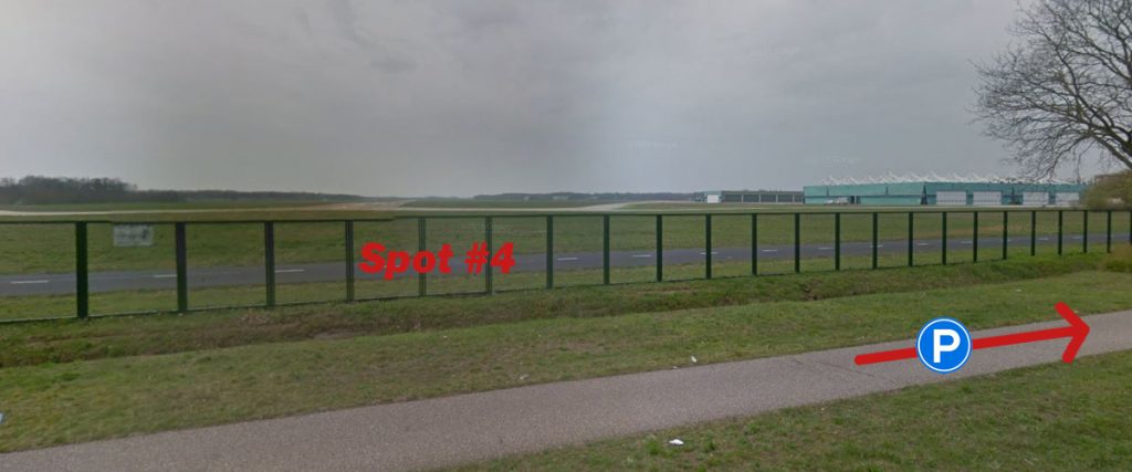
| Spot #4 – N282 side – Runway 20 | |
|---|---|
| WHERE | Park your car at parking a bit northwest here which is an abandoned company. Walk towards the fence to reach Spot #4. Stay at the road side of the ditch in the grass strip. |
| WHAT | Here you are able to take photos over the fence for helicopters linging up at Runway 20. Also you can take photos of helicopters parked at the Cargo Platform Area #7. Be aware that traffic at this spot is very limited, only during major exercises this spot is more often used. HERE a video example of this Spot. |
| TIME | Early morning until 10 o’clock the light is the best after this you will experience back light, or use this spot on cloudy days. |
| MISC. | You can go to the Shell station which is quite close here for toilet, sandwich and coffee. You need a pretty high ladder as the fence in 2.5 meters high. |
| FOCAL LENGTH | 300mm for helicopters lining up. 400+mm for shots on the Cargo Platform |
| Spot #5 – Broekstraat – Landing Runway 10 | |
|---|---|
| WHERE | Park your car next to the road at the Broekstraat. Make sure that you park your car well enough on the grass so other traffic can pass easily and then just shoot from the fieldside here. There is no stop for public traffic here. |
| WHAT | You can take shots of landing traffic at Runway 10. Walk along the road to find a decent spot. Planes are moving from left to right in this setting. |
| TIME | All day, this is a very good spot. |
| MISC. | There are no facilities here. Field can be dirty if it is rainy. |
| FOCAL LENGTH | Large aircraft with 250-300mm, small aircraft and helicopters with 400+mm |
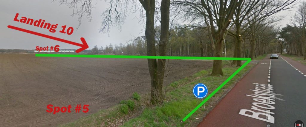
| Spot #6 – Fence West – 298 Squadron Platform | |
|---|---|
| WHERE | Park your car next to the road at Spot #5. Make sure that you park your car well enough on the grass so other traffic can pass easily. There is no stop for public traffic here. Walk along the fence to the corner of the field. Please respect the field of the farmer and don’t walk trough it, but stay along the fence of the base. |
| WHAT | Here you can get a glimpse of the Chinooks which are parked on the 298 Squadron Platform. For photos not the best spot, but ideal for reading serials of the parked helicopters. |
| TIME | All day, this is a very good spot. |
| MISC. | There are no facilities here. Ladder needed. |
| FOCAL LENGTH | You need at least a 500mm lens for photos at this spot. |
We cannot provide any example pictures yet. Please contact us if you have some!
| Spot #7 – Fence South – Slopes South | |
|---|---|
| WHERE | Park your car at the fieldside as marked on the map here and walk along the fence to this spot. Park your car along the small dirt road and make sure that farmer traffic can pass you there. Be aware that you are walking over the land of a farmer who is tolerating us here. Please don’t litter and only walk along the fence and not through his land. |
| WHAT | This is the location where the famous Slopes South shots are made. Helicopters practice here in slope training. Don’t expect too much traffic here, only one maybe two helicopters come here per day and also in many cases you go home with nothing. At this spot its all about quality not quantity as the helicopter come very close here with a fantastic background. If you have a scanner focus on the message “hop over to the slopes” to get ready for action. Also the hangar of the Historical Flight is located behind the slopes, you can take shots of aircraft taxiing from the hangar to the Runway 02. Here a few video examples of the Slopes South: https://www.youtube.com/watch?v=mBtPRWjMQ98 https://www.youtube.com/watch?v=9_HYKM-a6oI https://www.youtube.com/watch?v=9AjphPQ45XU |
| TIME | All day, this is a very good spot. |
| MISC. | There are no facilities here. A ladder is needed here as the fence is 2.5m high. |
| FOCAL LENGTH | Depending on the size of the helicopter 70-200mm is enough. For nice angles you can use up to 400mm. |
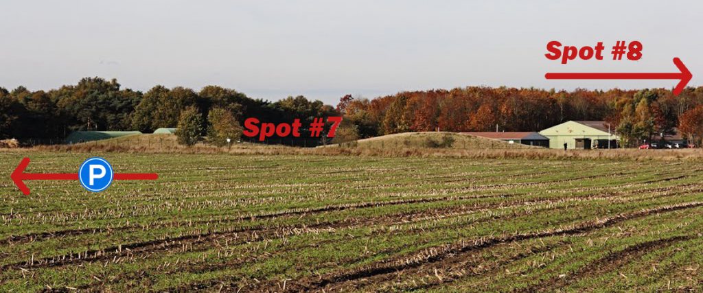
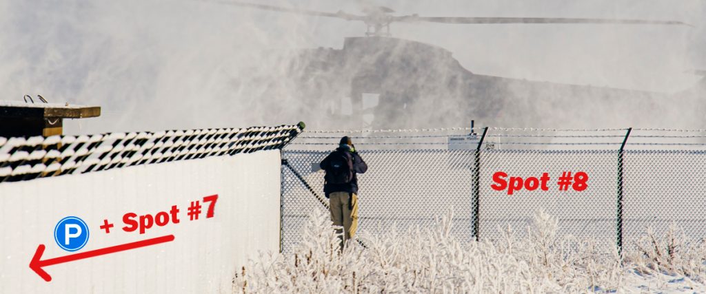
| Spot #8 – Fencekink – Runway 02 & Taxi Track | |
|---|---|
| WHERE | Park your car at the fieldside as marked on the map here and walk along the fence to this spot. Park your car along the small dirt road and make sure that farmer traffic can pass you there. Be aware that you are walking over the land of a farmer who is tolerating us here. Please don’t litter and only walk along the fence and not through his land. |
| WHAT | Here you can take photos of the helicopters hovering over the taxi track towards the slopes or helicopters which are in the circuit 02/20. Airplanes the Gilze-Rijen Historical Flight will often use this runway for take-off and landing making thias a very nice spot. |
| TIME | On the taxi track the light is always good. For the Runway 02, light is the best after 1200LT as you have back light in the morning hours. |
| MISC. | There are no facilities here. A ladder is needed here as the fence is 2.5m high. |
| FOCAL LENGTH | For frontal shots on the taxi track use 300 – 400mm for shots on during line up at Runway 02 only 70 – 200mm is needed. |


Question for spot 6. Is it possible to catch arrivals onto rwy 10 if you keep walking along the field road? Because it seems like you can get some shots of arriving traffic from there. I have a 250mm lens tha’s why i’m asking
10 Arrivals should work there, yes.
One of the best guides I’ve seen on here, will definitely visit in the future.